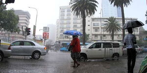

In the wake of relentless downpours that have besieged Kenya for months, an analysis of satellite imagery and weather forecasts offers a glimmer of hope as the country braces for the end of the deluge. However, even as the rain clouds dissipate, the toll of destruction left in their wake emerges as a stark reality.
Our examination of various data sources reveals a refreshing trend: the heavy rains that have plagued the nation since March are set to diminish as we progress into May. Particularly in Nairobi, Central, and Northeastern regions, a significant reduction in rainfall is anticipated by the third week of the month.
According to insights gleaned from Google GraphCast, an AI weather prediction model, the current week, spanning May 8th and 9th, will witness intense rainfall across several regions, including Nairobi, Kiambu, Kajiado, and Garissa.
The amount of rainfall in these areas will drop radically from an average of 20mm to a low of 2.5mm, with some areas being completely dry. Rainfall amounts are expected to range from 4 to 10mm, with localised spikes up to 25mm.
However, this reprieve from rain is not universal. Coastal and Nyanza regions are projected to endure heavy rainfall for the foreseeable future, with precipitation levels hovering between 6mm and 25mm over the next fortnight.
Corroborating our findings, data from reputable sources such as BBC Weather, VentuSky, and Meteox.com align closely, forecasting a general reduction in rainfall across the country to between -4mm and 6mm.
Meteox.com predicts a notable decrease in rainfall levels within the capital, Nairobi, from the previous highs of over 40mm to an average of 4.69mm starting May 13th. The forecast indicates a gradual tapering of rainfall, with figures ranging from 4.4mm on May 13th to a low of 2.5mm on May 24th.
The Kenya Meteorological Department echoes these sentiments, indicating that while certain regions may experience continued rainfall, overall intensities are expected to diminish in the latter half of the forecast period.
Nevertheless, the spectre of heavy rainfall events looms over various parts of the country, including the Rift Valley, Lake Victoria Basin, and the Southeastern lowlands.
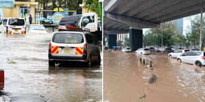
Amidst the glimmer of hope offered by the abating rainfall, the nation grapples with the grim reality of the devastation wrought by the floods.
Government figures paint a sobering picture: over 250 lives lost, while 293, 661 people have been affected and 54,837 households have been displaced.
Additionally, 61 health facilities have been affected in 11 Counties, and crops on approximately 9,816 acres of land have been destroyed. 44 cholera cases have been reported so far.
In addition to the human toll, the devastating floods have exacted a heavy toll on Kenya's agricultural sector and livestock population. Government reports reveal a grim reality, with over 4,000 livestock perishing as a direct consequence of the flooding.
Moreover, the inundation of vast swathes of agricultural land has led to the destruction of crops on over 7,500 acres, compounding the economic hardship faced by rural communities. With crops submerged under water or washed away by torrential rains, farmers grapple with the loss of income and livelihoods, with the threat of food security looming.

Government spokesperson Isaac Mwaura on Wednesday, May 8, pointed to the persistent nature of the flooding crisis, with forecasts indicating continued heavy rainfall and thunderstorms across 31 counties over the next few days heading into the weekend.
The affected regions span the Lake Victoria Basin, Rift Valley, Central, and Eastern regions, with sporadic rainfall also anticipated in Nairobi and coastal areas, including Tana River, Kwale, Mombasa, Kilifi, and Lamu Counties.
According to Mwaura, 192 dams are at a high risk of bursting, with 33 counties within 178 high-risk dams and water reservoirs.
Mwaura further highlights the ongoing threat posed by the swelling waters of Lake Victoria and Lake Baringo, which continue to inundate surrounding areas, exacerbating the flooding crisis in the respective basins.
The overflow of major dams, such as the Seven Forks Dams in the Central region, further compounds the risk of flooding, particularly in the Tana Delta, Garissa, Tana River, and Lamu Counties.