
The Nairobi County Government has called for a clear definition of boundaries at State House, Jomo Kenyatta International Airport (JKIA), Wilson Airport, the Department of Defence headquarters, and various military barracks in and around the city.
In a guide on Nairobi City Development Ordinances and Zones released by the City Planning Department, the key national installations were listed as places where clear boundaries were needed.
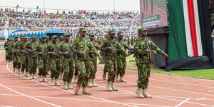
Aside from State House, the two airports, and the DOD, other areas listed include the Langata and Kahawa barracks, the military airbase in Eastleigh, the Defence College in Karen, and the Forces Memorial Hospital.
The guide provided prospective developers with general planning guidelines aimed at raising awareness on development control, easing the procedures for making development applications, and curtailing inappropriate or illegal developments.

Current Locations and Boundaries of State House, JKIA & Co.
State House Nairobi sits on State House Road off Dennis Pritt Road, beginning at the junction with Processional Way and extending across grounds bordered by Dennis Pritt Road, Arboretum, and State House Road. Nearby, the Department of Defence (DoD) is located along Lenana Road in Hurlingham, starting near Kilimani Police Station and covering land between Lenana Road, Hurlingham, and State House Avenue.
The city’s key airports include Jomo Kenyatta International Airport (JKIA) in Embakasi, which starts at the Airport South Road roundabout and stretches toward Embakasi Village, Mombasa Road (near Cabanas), and Syokimau; and Wilson Airport on Lang’ata Road, whose gate is opposite Nairobi National Park, with boundaries extending along Lang’ata Road, the park, and South C.
Adjacent to Wilson is Lang’ata Barracks, starting at its gate near Freedom Heights and running toward the Nairobi National Park fence and Karen. Along Thika Superhighway, Kahawa Barracks begins near Kenyatta University at the Kahawa Sukari junction, extending toward Kahawa Wendani, Kahawa West, and Roysambu.
Military support facilities include Moi Air Base in Eastleigh, which starts at Juja Road near Eastleigh Section III and stretches toward Mathare North and Pangani, with its runway visible from Juja Road. On Mbagathi Road, the Forces Memorial Hospital begins opposite Kibera and extends adjacent to Mbagathi Way and the Nairobi Arboretum, serving as the military’s central medical facility.
Impact of Clear Definition of Boundaries
But how would a clear definition of boundaries affect Nairobians and Kenyans in general?
The first effect would be in revenue collection and land rates. Nairobi County collects land rates, business permits, signage fees, and other levies within its jurisdiction. Installations such as State House sit on vast tracts of land, but their exact boundary definitions have often been a grey area because they are ‘national or strategic assets.’
A clear definition of boundaries would come in handy and prevent disputes on where county taxation applies, helping Nairobi align well with its revenues. On the flipside, most of these installations are national government properties, and are thus exempt from some county levies, meaning the county might discover it has less taxable land than assumed.
Another area that would require the attention of Nariobians would be in county administration. This will most likely be heavily felt in voting. If a boundary review reassigns land parcels, any residents, workers, or service personnel living within those areas would be reallocated to new constituencies/wards. Their voter registration records (kept by IEBC) would need updating.
Also, IEBC would need to re-map polling stations inside or near the re-demarcated areas. For example, polling centres serving JKIA staff/nearby estates might shift to new constituencies.
In the same breadth, voters in estates near JKIA or Lang’ata Barracks might find themselves assigned new polling centres further away or under different ward administrators. Families of security staff who previously voted in one constituency might need to transfer registration to another.
A practical example in redrawing JKIA’s boundaries would result in its removal from Embakasi East, stripping the constituency of thousands of voters tied to airport staff housing and relocating polling stations like Airport Primary. This would significantly shrink the voter register, reduce Embakasi East’s electoral weight, and potentially push it below the IEBC’s population threshold, triggering boundary adjustments and affecting resource allocation.
Clear definition of boundaries would also be felt in urban planning and zoning. Nairobi County is responsible for planning approvals, zoning regulations, and development control.
Clear boundaries would make it easier for the county to regulate building heights, land use, road networks, and business establishments around these sensitive zones.
This could apply well near Wilson Airport and JKIA, where the Kenya Civil Aviation Authority (KCAA) enforces air safety restrictions. County planning must align with these, so clear boundaries help prevent conflicts.
Another key effect of the clear definition would be felt in infrastructure and service provision. The county provides roads, waste collection, water distribution, and fire services.
If boundaries are clearly defined, Nairobi can better allocate resources such as where county garbage trucks should collect, where fire hydrants are required, or where drainage responsibilities lie. It also avoids duplication of work with the national government agencies that already service installations like JKIA and Langata Barracks.
Security and jurisdiction will be another critical effect of such a boundary review.State House, barracks, and airports are strategic national security installations. Nairobi County has limited jurisdiction inside them, but defining boundaries removes ambiguity about where county enforcement officers can operate versus where only national security agencies are in charge. This could reduce clashes, such as past disputes between county askaris and military/police over encroachment or land grabbing.
As per City Planning Director Patrick Odongo, the planning ordinances will be shared with interested stakeholders to ensure that development control, and indeed the wider planning agenda, would be implemented effectively across the city.