
A section of Kenya's 2nd longest river (Athi-Galana) has turned completely black.
On August 10, photos of this section of the river turned viral across social media platforms, with Kenyans calling on the National Environment Management Authority (NEMA) to look into the matter.
Speaking to Kenyans.co.ke, NEMA communications manager Evans Nyabuto revealed that the authority was looking into the matter.
According to the reports, the section of the river that turned black is believed to around the factory-filled Mavoko area.

"Athi-Galana river has changed color to completely black. On part of its course through Athi River town heading through to Fourteen falls," Philip Ndegwa, a concerned citizen reported.
Speaking to Kenyans.co.ke, Ndegwa estimated that the section of the river that had turned black stretched for several Kilometres, as he took the photos from Kangundo Road towards Joska.
He further opined that the discoloration is likely to have emanated from a textile or steel firm in the area.
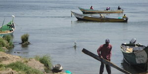
A closer look at the alarming photos further showed a greater danger as local farmers are seen to use the very same water to irrigate their farms along the river's banks.
Plastic pipes used to pump the murky water from the river and over its steep banks are visible from the photos.
The Athi-Galana-Sabaki River is the second longest river in Kenya (after the Tana River).
It has a total length of 390 kilometres, and drains an area of 70 square kilometres. it rises in the Gatamaiyo Forest as the Athi River and enters the Indian Ocean as the Galana River (also known as the Sabaki River).
The river which is vital for Kenya's ecosystem, snakes across the Kapote and Athi plains, through Athi River town, then takes a northeast direction where it is met by the Nairobi River. Near Thika, the river forms the Fourteen Falls and turns south-south-east under the wooded slopes of the Yatta ridge.
According to Lotus Africa's survey report titled Water Pollution Crisis Kenya 2019 – Statistics, Causes & Impact, most of the city’s rivers are flooded with garbage, mostly plastics. Sewage sludge is released into rivers, giving the illusion that the river is non-existent.
The pollution of these rivers is due to the fact that people throw garbage in the rivers and along their banks.
Many water bodies near urban areas (towns and villages) are highly polluted. This results from both garbage discarded by individuals and hazardous chemicals legally or illegally dumped by manufacturing industries, health centers, schools and markets.
The report further revealed that water pollution in Kenya is very harmful to humans, animals and aquatic life.
The effects can be catastrophic, depending on the type of chemicals, pollutant concentrations and where they are polluted.
On July 24, residents of Nakuru were left puzzled after 'black rain' pounded various parts of the county.
The startling reports were described as strong indicators of the emergence of air pollution.

KNEC Releases 2025 KJSEA Results, How to Check Breaking News